* Druid House and the Druid Estate *
Historic England says that Druid house, which consists of a large house and stable, looks early 19th century.https://historicengland.org.uk/listing/the-list/list-entry/1200962?section=official-list-entry - accessed 15-11-2024
Thomas White Windeatt, of Totnes, married Mary Fabyan of Ashburton in May 1803.
Mary Fabyan Sparke was one of the witnesses.
Parish records
At the time of the tithe apportionments (1836 onwards) William Fabyan Windeatt was the owner of Druid House and plantation. John Sparke Amery was listed as the occupier.
https://new.devon.gov.uk/historicenvironment/tithe-map/ashburton/ - accessed 15-11-2024
John Sparke Amery married Frances, daughter of the Rev T W Windeatt of Totnes, in 1838, According to his obituary he retired from the woollen industry in 1846 and 'turned his attention to farming, especially to the improvement of the lately-enclosed common land at Druid, near Ashburton.'Transactions of the Devonshire Association, 1878, vol 10, p51
https://archive.org/stream/ReportTransactionsOfTheDevonshireAssociationVol101878/TDA1878vol10_djvu.txt
A lode of tin was allegedly discovered on the Druid Estate in 1851.
Western Times 24 May 1851 p7 col2
In 1852 John Sparke Amery of Druid, Ashburton, James Whitton Arundell of 11 Chancery Lane, Middlesex, William Williams of Buckfastleigh, (mining agent ) and Edward Preston Walker of Arlington Street, Middlesex, entered into a 7 year lease 'To search for ores, metals and minerals in Druid and Rew Down'
The documents, ref 2180/7 1852, are held at the Plymouth and West Devon Record Office.
May 1852 The Wheal Arundel Mine was opened on the Druid Estate, belonging to John Sparke Amery. Capt Williams was the superintendent.
Western Times 8 May 1852 p7 col3
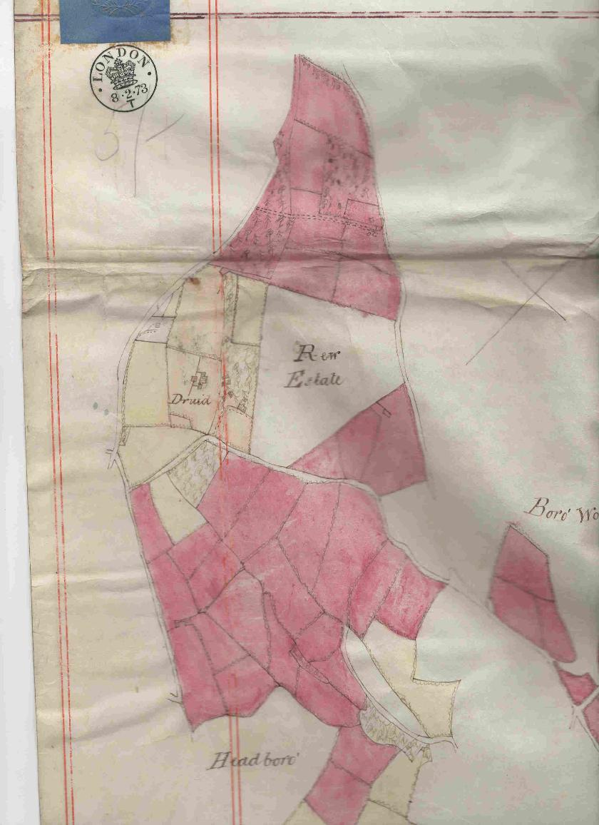
A 28 year lease in 1873 was for 'All manner of mines and veins of tin, tin ore, copper, copper ore, lead, lead ore, and all other ores, metals and minerals whatsoever...that may be found out by observation digging sinking shafts or otherwise'. The area involved was the Druids Estate or the fields near the Borough Wood, excepting the Borough Wood Estate and the Lower Boadley Estate, together with Druid House and Druid Cottage. The lease did not cover the Plantation behind Druid House ('as far as the top of Kitly Park') or the field called The Paddock in front of the house, plus Lower Moor or Cottage Meadow, Higher Moor, Water Turn, or King's Close - all the areas coloured yellow on the map.Documents in my possession. For more on the Druid Mine, see Quarries and Mines, under Banks and Businesses
* *** *
In July 1890 the first resolution of the newly formed Ashburton Building Company was to accept the plans of Mr Rowell of Newton Abbot to build near Rew on the Druid Estate, which the Amery family owned. Mr F Amery (almost certainly Peter Fabyan Sparke Amery) was chairman of the directors, and John Sparke Amery [Jnr] was also at the meeting.The land leading to the Rew Down Cross properties was at that time called Stone Carriers' Lane, later changed to Druid's Lane.
Document from my own collection
For more on the Ashburton Building Company, see under Banks and Businesses
In November 1890 Peter Fabyan Sparke Amery agreed to lease land to Edward Windeatt of Totnes 'In consideration of the erection and completion to the satisfaction of the said P F S Amery of the messuages and premises hereinafter mentioned..'
The land was 'bounded on the north by public road called Stone Carriers' Lane on the south by the remainder of field number 356 on the east by right of way leading to remainder of field and the west by lands of P F S Amery called Longmeadow...'
Indenture 11th November 1890 and indenture 23rd December 1907 amongst the deeds of Cartlands. Many Thanks to Roger Tilley for allowing me to see these.
* *** *
Peter Fabyan S Amery died aged 67 in the September quarter of 1907, in the Newton Abbot registration district.https://www.freebmd.org.uk
65 year old John Sparke Amery and his 58 year old cousin Jasper John Amery are at Druid, Ashburton, for the 1911 census. Both are single and living on private means - in addition, John Sparke Amery is a farmer.
1911 census RG14, piece no. 12726
Druid Plantations were filled by Canadians in the 14-18 war. Ausewell Hill was made impassable by the lumber waggons'.Note made by Mr. or Mrs. Hatch, pre 1998. Source of information unknown.
Thanks to Jeremy Hatch for this document.
75 year old John Sparke Amery was at Druid for the 1921 census. He was a 'private gentleman' and farmer, with a housekeeper, Anne Rowland, 77, a cook, Annie M Caunter, and a servant, 15 year old Alice J R Crawford.
1921 census RG15, piece no. 10435, schedule 69
John Sparke Amery (Jnr) JP, born 1845, died in April 1929
Ashburton Archive https://ashburtonarchive.org.uk/ - accessed 19-11-2024
Edward Fabyan Windeatt of Druid, Ashburton, is listed in a book of remembrance and war record of Mill Hill School. He was a senior company officer of the NFS (National Fire Service) from 1942-45, engaged in the administrative side of the service, particularly disciplinary matters. He was in the part-time fire service from 1938-42, and assisted during the Plymouth Blitz and later at Exeter.Accessed in 2016 from an online Book of Remembrance of Mill Hill School - no longer available online
Mildred Alice Windeatt of Druid, Ashburton, died in May 1964. Probate was granted to Edward Fabyan Windeatt, solicitor, and Ruth Mary Windeatt, spinster. The valuation was £22739.
England and Wales Government Probate Death Index 1858 -2019
Ruth M Windeatt and Edward F Windeatt were at Druid House on the Register of Electors 1965/66See whole register under People and Properties

